
Archive Record
Images
Metadata
Object ID |
2015.035.001 |
Title |
United Air Lines Mainliner Fleet map |
Accession number |
2015.035 |
Object Name |
Map |
Scope & Content |
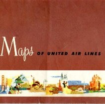
Two sided map of the routes used by United Air Lines fleet as drawn by Hal Shelton. One side has the Western portion of the United States with two insets of the Hawaiian islands and the island of Oahu. The top portion of this side has the "Key to Map Symbols" and a description of the weather routes the flights take throughout the United States. The opposite side has the Eastern portion of the United States. The top portion of this side has the main map cover which details the United Air Lines Mainliner Fleet with images of the different planes. The opposite side as the title "Your Air Maps of United Air Lines: System Map coast-to-coast, border-to-border, and on to Hawaii". |
Pub Date |
1956 |
People |
Shelton, Hal |