
Archive Record
Images
Metadata
Object ID |
2017.077.003.a-.e |
Title |
Aerial Photos of Golden & cover letter |
Accession number |
2017.077 |
Object Name |
Fonds |
Scope & Content |
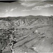
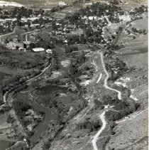
This is a collection of aerial images of Golden. There is a cover letter, two original prints, and 13 photocopies. 2017.077.003.a-e Identity Statement: Lynn Yehle Geological and Historical Research Records: Aerial Photographs Dates of Creation:1932, 1933, 1935 Scope and Content / Abstract: This is a collection of aerial images of Golden. There is a cover letter, two original prints, and 13 photocopies. 003.aA 2012 letter from Lynn Yehle to the Golden History Museum. The letter gifts to the museum the photographs and documents included in this collection. It summarizes the origins of the photographs and describes the photocopies. 003.bAn 8" x 10" black and white aerial photograph from 1932 or 1933. The following is from Yehle's 2012 letter (003.a): "1932 or 1933: By T.S. Lovering. Out of the U.S. Geological Survey's National photo library, Denver Federal Center. Lovering had two photo runs with King Air to extensively illustrate a major report (with VanTuyl as senior author) entitled, Physiographic development of the Front Range, Geologic Society of America, Bulletin 46 (9), p. 1291-1349, 108 plates, 1935. This photo is on plate 103, fig. 2 (left side), opposite p. 1344, it is west-viewing, up Clear Creek valley, shows much of the south part of North Table Mountain; background is the Rocky Mountain Front Range". "In the report there are other interesting photos of the mountains and nearby, including one of part of north Golden (enclosed, several magnifications) viewing west, plate 107,fig 2, opposite p.1348". The photo also includes the Clear Creek Valley between North and South Table Mountains and the northern parts of the City of Golden: Coors, Church Ditch, Texaco gas station, Connors mine, Colorado School of Mines, Lariat Loop Road, Denver and Northwestern Railroad, and the Colorado and Southern Railroad. The snow-capped mountains of the Front Range are visible on the horizon. Two photocopies (one 8.5" x 11" and one 11" x 17"), enlargements of the original, are also included. 003.cAn 8" x 10" black and white photographic enlargement of central lower part of photograph 0003.b. The enlargement is of the north side of the Clear Creek Valley and the northern sections of the City of Golden. Three photocopies (one 8.5" x 11" and two 11" x 17"), enlargements of this enlargement, are also included. These photocopies have annotations identifying various features. 003.dA set of seven photocopies (three 8.5" x 11" and four 11" x 17") of a July 23, 1937 aerial photograph. The photograph shows the Clear Creek Valley between the North and South Table Mountains, portions of the tops of the North and South Table Mountains, and the City of Golden. 003.eA 11" x 17" photocopy of a October 21, 1948 aerial photograph. The image covers an are of about 0.4 miles north/south and 0.3 miles east/west showing the south central flank of North Table Mountain and the Clear Creek Valley at its base. Search Terms Golden Coors Colorado School of Mines Metallurgical Research Center (CSMRC, CSMRI) Church Ditch North Table Mountain Clear Creek Texaco Gas Station Connors Mine Denver and Northwestern Railroad Colorado and Southern Railroad Lariat Loop Road |
People |
Yehle, Lynn A. |
Search Terms |
Colorado School of Mines Church Ditch North Table Mountain Clear Creek Denver & Northwestern Railroad Colorado & Southern Railroad Lariat Loop |